You know the feeling. It's early October, the aspens are doing their thing, and you've got a weekend and a tank of fuel. The forecast for the town at the bottom of the canyon says 58 and sunny. The forecast is not the problem. The problem is the eleven thousand feet between you and the other side of the pass, and whether anything landed up there on Tuesday night.
Grover's map has two new chips for exactly that. Open the map drawer, look at the Conditions row, and you'll find Snow Depth and New Snow 24h sitting next to the fire and smoke toggles.
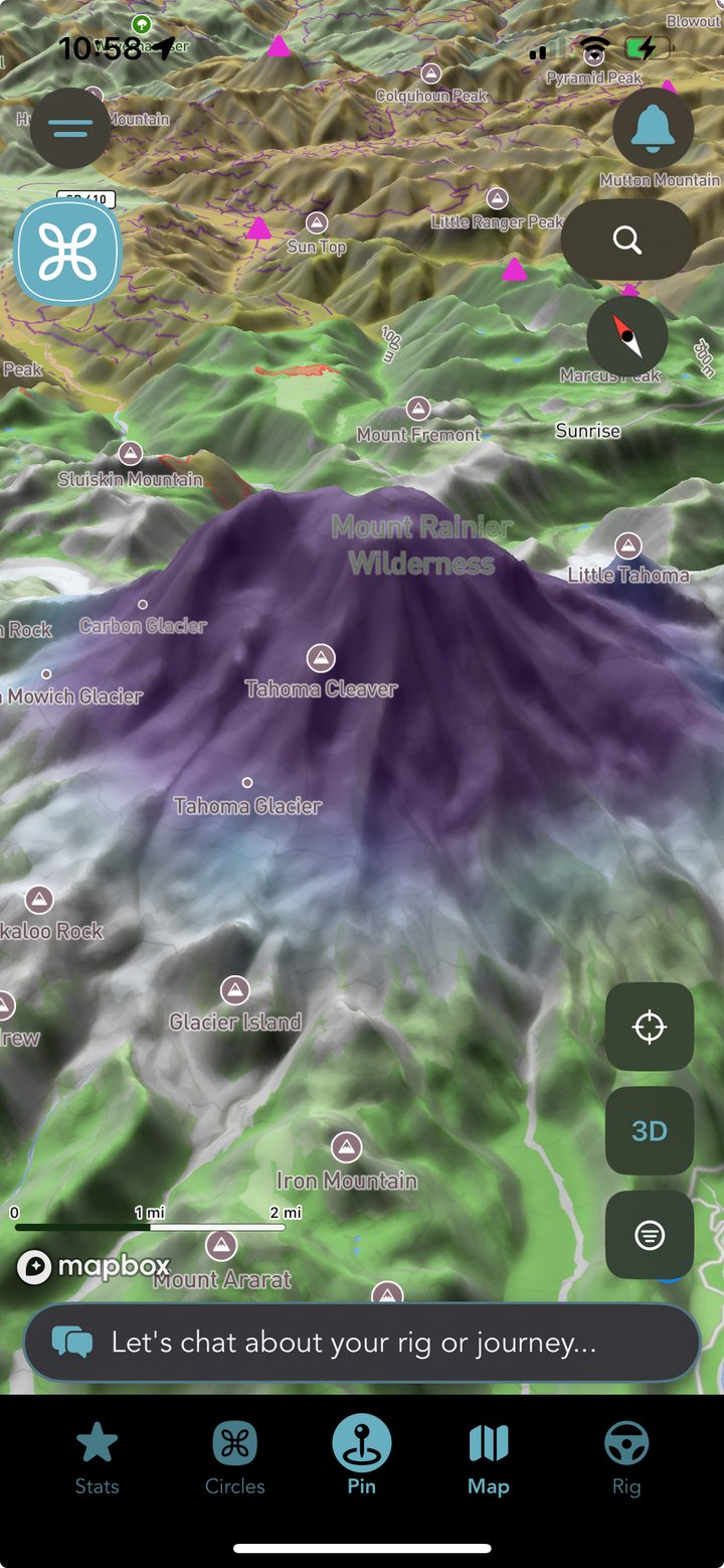
Rainier in September. Purple is deep, and almost all of it is above the treeline.
Snow Depth: What's Actually on the Ground
This is the standing snowpack. Not what's forecast, not what fell last week, what is sitting there right now. It paints across the map in blues that deepen toward purple, and the scale runs from an inch through six inches, a foot, two feet, and on up past five feet where the high country earns it.
Tap the Snow Legend chip at the end of the Conditions row and the whole ramp opens up band by band, so you can tell a dusting from a thigh-deep trudge without squinting at a color and guessing. That legend is generated from the same data that colors the map, so the swatches and the ground always agree.
It's the layer that answers the question you're actually asking: is that trailhead still a trailhead, or is it a snowfield with a sign in it?
New Snow 24h: What Showed Up Overnight
Depth is a state. This one is an event. New Snow 24h shows what fell in the last day, starting at a trace and climbing through one, three, six, twelve and eighteen inches, and it's drawn brighter than depth so the two read apart when you have both turned on at once.
We kept them as two separate chips on purpose rather than blending them into one "snow" number, because they answer completely different questions and their seasons don't even line up. Depth tells you what you'd be parking on. New snow tells you what the pass just did to your Saturday.
Turn It On Today and You'll See Almost Nothing
That is the layer working, and it's worth explaining. Both of these products are genuinely empty for about half the year across most of the country. On the morning we published this, there were 254 snow-carrying grid cells in the entire Lower 48, all of them stacked on the high peaks, and fresh snowfall was flat zero nationwide.
A blank overlay with no explanation just reads as a broken feature, so Grover says it out loud instead. When there's nothing to draw, the layer tells you there's no snow today rather than leaving you to wonder whether the map failed. Come November it fills in, and the chip will already be sitting in your drawer where you left it.
Which makes right now the good time to go find it, not the wrong one.
Where the Data Comes From, and What It Isn't
Both layers come from NOAA's National Operational Hydrologic Remote Sensing Center, the same public source that feeds the snow maps hydrologists and avalanche centers work from. Snow depth comes from SNODAS and fresh snowfall from SFAV2. We're not modeling snow ourselves, we're putting what NOAA already publishes onto the map you're already looking at.
Read it before you pick a route, not instead of checking the pass. These are modeled estimates on a roughly one kilometre grid, which is wonderful for "is there winter up there" and useless for "is this specific forest road drivable." They also cover the Lower 48 only and stop dead at the Canadian border. For road and pass conditions, your state DOT's 511 line is still the authority, every time.
It lives in the same Conditions row as the fire and smoke layers, in the same drawer that split into Layers and Filters earlier this year. Turn on what you need for the trip in front of you, leave the rest off, and the map stays readable.
Both Phones, Right Now
Snow depth and new snowfall are live on iOS and Android in version 1.3.2. If your app updates itself you already have them, and if it doesn't, this is a good week to fix that.
Go See What the High Country Is Doing
Download Grover, open the map drawer, and turn on Snow Depth. Then check it again in November and watch the whole spine of the Rockies light up.